22 May 2025
New Frontier Minerals Limited
("NFM" or the "Company")
NFM advances NWQ Copper Project with bulk samples to Mt Kelly Processing Plant
New Frontier Minerals Limited ("New Frontier", or "the Company") (ASX and LSE: NFM) is pleased to announce it has completed a strategic site visit to Austral Resources' Mt Kelly Copper Processing Plant in Queensland, representing a critical milestone in advancing NFM's flagship NWQ Copper Project towards production.
Located in the prolific Mt Isa Copper Belt (figure 1), NFM's NWQ Copper Project offers a unique opportunity to leverage world-class infrastructure and regional expertise via a MOU with Austral Resources to process ore from NWQ at Austral's Mt Kelly facility, fast-tracking NFM's pathway to copper production.
NFM's Non-Executive Director and geologist Joel Logan, inspected Mt Kelly for insights into the plant's capacity to support NFM's production plans, particularly for its flagship Big One Deposit. The visit also reinforced the scalability and economic potential of NFM's collaboration with Austral Resources, highlighting the NWQ Copper Project's position in one of the world's richest copper regions.
Highlights:
· Site visit to Austral Resources' Mt Kelly Copper Processing Plant reinforces NFM's collaboration and production plans for its NWQ Copper Project
· Bulk samples collected from historical stockpiles at the Big One Deposit for copper processing evaluation at Mt Kelly Processing Plant
· NFM has a Memorandum of Understanding (MOU) with Austral Resources to process copper from the Big One via Austral's Mt Kelly facility, fast-tracking NFM's pathway to copper production
· Positioned in Australia's premier copper province, the NWQ Copper Project features world-class infrastructure and vast exploration potential across more than 20 under-explored targets
· NFM plans to Progress Mining Lease Applications and regulatory requirements over the Big One Deposit while commencing metallurgical testing of existing copper oxide stockpiles to fast-track near-term copper production
Ged Hall, Chairman, commented: "Our successful site visit to Austral Resources' Mt Kelly facility and the formalisation of our strategic alliance marks a milestone in our growth strategy. These advancements provide a clear path to production for NFM, leveraging world-class infrastructure and partnerships to create significant value for our shareholders. We are confident that the NWQ Copper Project will emerge as a standout asset within one of the world's premier copper belts."
Copper Demand Context
The advanced infrastructure at the Mt Kelly processing facility aligns with NFM's production strategy. Discussions with regional stakeholders further underscored the growing demand for copper, driven by global decarbonisation and electrification efforts and developing economies. This macroeconomic trend continues to bolster confidence in the project's strategic importance and long-term value.
NWQ Copper Project Background
The Big One Deposit is the most advanced prospect within NFM's significant 977km² NWQ Copper Project, which is in a Tier 1 jurisdiction and surrounded by world-class infrastructure as well as mining operations of majors such as Anglo American, Glencore, and Rio Tinto. It has a JORC-compliant Mineral Resource Estimate (MRE) of 2.1 Mt at 1.1% Cu for 21,886 tonnes (see Appendix A) of contained copper metal and boasts more than 20 under-explored (refer to Appendix A reference list) targets highly prospective for copper mineralisation, offering substantial exploration potential.

Figure 1: NWQ Copper Project in Mt Isa Copper Belt. Gunpowder denotes location of Mt Kelly Processing Plant
Strategic Alliance with Austral Resources
A formalised Memorandum of Understanding (MOU) between NFM and Austral Resources1 sets the foundation for a strategic alliance to drive copper production and deliver shared benefits. Combining NFM's exploration and mining expertise with Austral's advanced copper processing facilities at Mt Kelly, creates a scalable and competitive asset base. Under the agreement, Austral secures a consistent source of high-grade copper ore, while NFM fast-tracks its pathway to potential production.
The alliance prioritises the supply of copper ore from NFM's Big One Deposit, with the potential to expand to additional satellite targets within the NWQ Copper Project. Metallurgical test work will be conducted to ensure NFM ore meets processing standards, and a profit-sharing model ensures equitable value creation for both parties. The partnership also positions the alliance as a strong contender within a region dominated by leading global miners (figure 2), offering strategic advantages and significant growth potential.

Figure 2: Mt Isa Copper Belt - Major Players (Source: NFM Geology Team)

Figure 3: Jointing and shearing displayed along face of Pit 1 at the Big One Deposit
Source: NFM Geology team, Location Figure 3: 335394 mE and 7880283 mN system MGA94-Z54S

Figure 4: Disseminated azurite and malachite alteration throughout silicified sedimentary unit at BOGS3 Site
Source: NFM Geology Team, Location Figure 4: 335471 mE, 78880362 mN
Visual Estimates ASX Disclosures - Figures 4 through to 7
Figures 4 through to 7 show samples of mineralised rocks, typical of those found from the three ex-mine dumps in and around the mined areas at Big One that have been sampled to obtain just over 200Kg of material. The mineralisation found in the dump material is highly to moderately weathered and altered copper carbonates, oxides, and some chalcocite (see Figures 8 and 9). Exact minerals present and their concentrations will be confirmed by XRD and/or SEM as part of the metallurgical testing ordered.
This material is destined for detailed multi-element assay and metallurgical testing by both Austral Resources and the ALS Laboratory at Mt Isa. Results from this testing will be available in one to two months' time. More details of these bulk samples are given in Appendix B following, which also lists an estimate range of copper concentration that will be updated by laboratory assay.
Cautionary Statement
Visual estimates of mineral abundance should never be considered a proxy or substitute for laboratory analyses where concentrations or grades are the factor of principal economic interest. Visual estimates also potentially provide no information regarding impurities or deleterious physical properties relevant to valuations.

Figure 5: Kaolinite-altered trachyte dyke, disseminated malachite and chrysocolla at BOGS3 Site
Source: NFM Geology Team, Location Figure 5: 335471 mE, 78880362 mN
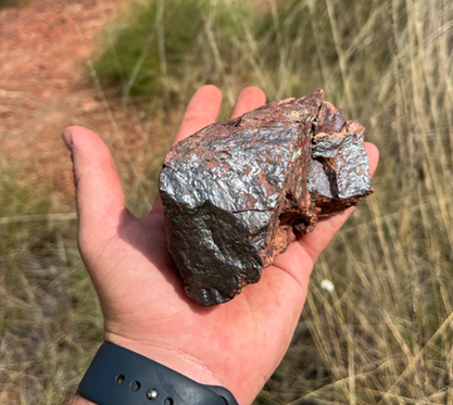
Figure 6: Oxidised Chalcocite mineralisation at BOGS1 Site
Source: NFM Geology Team, Location Figure 6: 335352 mE, 78880348mN

Figure 7: Mineralised trachyte dyke (left) and sedimentary unit (centre-right) at BOGS1 Site
Source: NFM Geology Team, Location Figure 7: 335352 mE, 78880348 mN

Figure 8A: Historical stockpile BOGS1 where grab samples were collected
Source: NFM Geology Team, Location Figure 8A: 335352 mE, 78880348mN

Figure 8B: Historical stockpile where BOGS2 grab samples were collected
Source: NFM Geology Team, Location Figure 8B: 335453 mE, 78880348 mN

Figure 9: Various lithologies and forms of copper mineralisation from sampled stockpile BOGS3
Source: NFM Geology Team, Location Figure 9: 335471 mE, 78880362 mN

Figure 10: Total drums containing grab sample material collected to be processed at the Mt Kelly Processing Plant
Source: NFM Geology Team, Location Figure 10: 335352 mE, 78880348 mN
Next steps
NFM's near-term plans to release its ambitions include:
· Progress Mining Lease Applications and regulatory requirements over the Big One Deposit
· Metallurgical testing of existing copper oxide stockpiles to fast-track near-term production
· Drilling to increase the resource base at the Big One Deposit and explore other satellite targets
· Collaborate with Austral Resources to define a comprehensive work programme focused on delivering production milestones efficiently
For further information please contact
|
New Frontier Minerals Limited |
+61 8 6558 0886 |
|
Gerrard Hall (UK), Chairman |
|
|
|
|
|
SI Capital Limited (Financial Adviser and Corporate Broker) |
+44 (0)1483 413500 |
|
Nick Emerson |
|
|
|
|
|
Gracechurch Group (Financial PR) |
+44 (0)20 4582 3500 |
|
Harry Chathli, Alexis Gore, Henry Gamble |
|
About New Frontier Minerals
New Frontier Minerals Limited is an Australian-based focussed explorer, with a strategy to develop multi-commodity assets that demonstrate future potential as an economic mining operation. Through the application of disciplined and structured exploration, New Frontier has identified assets deemed core and is actively progressing these interests up the value curve. Current focus will be on advancing exploration activity at the Harts Range Niobium, Uranium and Heavy Rare Earths Project which is circa 140km north-east from Alice Springs in the Northern Territory.
Other interests include the NWQ Copper Project, situated in the copper-belt district circa 150km north of Mt Isa in Queensland and the Broken Hill Project in western New South Wales.
New Frontier Minerals is listed on the LSE and ASX under the ticker "NFM".
Competent Persons Statement
The scientific and technical information in this announcement, which relates to exploration results and the geology of the deposits described, is based on information compiled and approved for release by Mark Biggs. Mark Biggs is a Member of The Australasian Institute of Mining and Metallurgy (AusIMM Member # 107188) and meets the requirements of a Competent Person as defined by the 2012 Edition of the Australasian Code for Reporting of Exploration Results, Mineral Resources and Ore Reserves (JORC Code 2012 Edition). Mark Biggs has 35 years of experience relevant to Rare Earth Elements (REE), industrial mineral copper mineralisation types, as well as expertise in the quality and potential mining methods of the deposits under consideration. Additionally, he has 25 years of experience in the estimation, assessment, and evaluation of exploration results and mineral resource estimates, which are the activities for which he accepts responsibility. He also successfully completed an AusIMM Online Course Certificate in 2012 JORC Code Reporting. Mark Biggs is a consultant with ROM Resources and was engaged by New Frontier Minerals Limited to prepare the documentation for several prospects, specifically those within the Harts Range Prospects upon which the Report is based.
Furthermore, the full nature of the relationship between himself and New Frontier Minerals Limited has been disclosed, including any potential conflicts of interest. Mark Biggs is a director of ROM Resources, a company that is a shareholder of New Frontier Minerals Limited, and ROM Resources provides occasional geological consultancy services to New Frontier Minerals Limited.
The Report or excerpts referenced in this statement have been reviewed, ensuring that they are based on and accurately reflect, in both form and context, the supporting documentation relating to exploration results and any mineral resource estimates. The release of the Report and this statement has been consented to by the Directors of New Frontier Minerals Limited. Mr Biggs consents to the inclusion in this announcement of the matters based on his information and supporting documents in the form and context in which it appears.
Forward Looking Statements
Certain information in this document refers to the intentions of New Frontier Minerals Ltd, but these are not intended to be forecasts, forward-looking statements, or statements about future matters for the purposes of the Corporations Act or any other applicable law. The occurrence of events in the future is subject to risks, uncertainties and other factors that may cause New Frontier Minerals Ltd's actual results, performance, or achievements to differ from those referred to in this announcement. Accordingly, New Frontier Minerals Ltd, its directors, officers, employees, and agents, do not give any assurance or guarantee that the occurrence of the events referred to in this announcement will occur as contemplated. The interpretations and conclusions reached in this announcement are based on current geological theory and the best evidence available to the authors at the time of writing. It is the nature of all scientific conclusions that they are founded on an assessment of probabilities and, however high these probabilities might be, they make no claim for complete certainty. Any economic decisions that might be taken based on interpretations or conclusions contained in this announcement will therefore carry an element of risk. The announcement may contain forward-looking statements that involve several risks and uncertainties. These risks include but are not limited to, economic conditions, stock market fluctuations, commodity demand and price movements, access to infrastructure, timing of approvals, regulatory risks, operational risks, reliance on key personnel, Ore Reserve and Mineral Resource estimates, native title, foreign currency fluctuations, exploration risks, mining development, construction, and commissioning risk. These forward-looking statements are expressed in good faith and believed to have a reasonable basis. These statements reflect current expectations, intentions or strategies regarding the future and assumptions based on currently available information. Should one or more of the risks or uncertainties materialise, or should underlying assumptions prove incorrect, actual results may vary from the expectations, intentions and strategies described in this announcement. No obligation is assumed to update forward-looking statements if these beliefs, opinions, and estimates should change or to reflect other future developments.
REFERENCES
[1] NFM ASX Announcement: Strategic alliance with Austral Resources to process NFM copper ore, dated 21 January 2025
APPENDIX A: 2022 MINERAL RESOURCE ESTIMATE
A maiden 2012 JORC Inferred Resource of 2.1Mt @ 1.1% Cu (Figure A1-1) was reported to the ASX in 2022 and a well-placed drilling programme focussing on diamond coring has the potential to greatly increase this number and confidence class, as the deposit is open to the east and downdip. The resource estimate included some areas adjacent to and downdip to the main resource shell which have sufficient information that allows estimation of an Exploration Target[1] mid-range of 0.76Mt @ 0.8-1.2 % Cu (Table 1). A new, small Indicated mineral resources estimate of mine stockpiles (from previous 1996 mining) has also been included.
Figure A1-1: Resource Tonnages Big One Mine Project
|
Tenure Name |
Ore Type |
Exploration Target Range Low (Mt) |
Exploration Target Range High (Mt) |
Exploration Target Range Mid (Mt) |
Inferred (Mt) |
Indicated (Mt) |
Measured (Mt) |
Copper Grade % |
Silver Grade g/t |
Contained Copper (t) |
Contained Silver (kg) |
|
Mine Dumps |
Oxidised |
0 |
0 |
0 |
0 |
0.007 |
- |
1.2 |
4.0 |
86 |
29.6 |
|
Mine Insitu |
Oxidised |
0.02 |
0.10 |
0.06 |
1.7 |
0 |
- |
1.0 |
1.1 |
17,000 |
1,870 |
|
Mine Insitu |
Fresh |
0.2 |
1.2 |
0.7 |
0.4 |
0 |
0 |
1.2 |
1.4 |
4,800 |
560 |
|
Sub-Totals |
|
0.22 |
1.3 |
0.8 |
2.1 |
0.007 |
0 |
|
|
21,886 |
2,459.6 |
References
Biggs M.S., (2022), Big One Mine, Updated Mineral Resource Estimate, prepared by ROM Resources for Castillo Copper Limited, unpublished memo, Feb 2022.
Castillo Copper Limited. (2019). Mt Oxide Project. Retrieved July 1, 2019, from Castillo Copper Limited: https://www.castillocopper.com/project-mt-oxide/
2 It should be noted that the Exploration Target tonnage range quoted above are conceptual in nature and there has been insufficient exploration to define a copper resource. Although a preliminary analysis was undertaken, insufficient data exists to confidently correlate mineralised horizons within the Exploration Target area. It is uncertain whether further exploration may lead to the reporting of a JORC-standard resource however there is some evidence to support the current exploration tonnage calculations, and the sufficient mineralised thicknesses interpreted from historical drilling to warrant further investigation in some areas.
APPENDIX B: NEW SAMPLE DETAILS
Fourteen (14) sample containers of new rock chip samples (as shown in Figure 10) were collected at three (3) ex-mine dump sites and are listed in Figure A1-1 below and their locations shown on the plan as Figure A1-2 following. Approximately 200 Kg was collected.
FIGURE A1-1: SAMPLE DESCRIPTIONS
|
Sample ID |
Location |
Easting |
Northing |
Copper Estimate Range% |
Description |
Date Collected |
|
BOGS1 |
Big One |
335352 |
7880348 |
2-4% |
Significant malachite, azurite and chalcocite mineralisation throughout the stockpile. Evidence of sheared rock. Clay altered trachyte dyke contains of malachite and chrysocolla. Minor tenorite and cuprite present. Visible lithologies include siltstone, greywacke, sandstone, and trachyte dyke. Some sections of the host rock are highly silicified. ~67kg of stockpile material has been grab sampled. |
10/05/2025 |
|
BOGS2 |
Big One |
335453 |
7880348 |
1-3% |
Significant malachite and azurite mineralisation throughout the stockpile. Trace chalcocite and tenorite. Clay altered trachyte dike contains of malachite and chrysocolla. Seems that the trachyte contains almost exclusively chrysocolla and malachite. Trace tenorite present. Visible lithologies include siltstone, greywacke, sandstone, phyllite/schist, trachyte dike and limestone (minor carbonate boxwork). ~69kg of stockpile material has been grab sampled. |
10/05/2025 |
|
BOGS3 |
Big One |
335471 |
7880362 |
1-3% |
Malachite, azurite and chrysocolla comprise the copper mineralisation of this stockpile. Visible lithologies include siltstone, greywacke, sandstone, and trachyte dike. ~65kg of stockpile material has been grab sampled. |
10/05/2025 |
Note:
Visual estimates supported by PXRF readings, but NFM awaits full laboratory testing. Visual estimates of mineral abundance should never be considered a proxy or substitute for laboratory analyses where concentrations or grades are the factor of principal economic interest. Visual estimates also potentially provide no information regarding impurities or deleterious physical properties relevant to valuations.
FIGURE A1-2: SAMPLE LOCATIONS

Source: NFM Geology Team, coordinate system is MGA94-Z54S
APPENDIX C: JORC CODE, 2012 EDITION - TABLE 1
The following JORC Code (2012 Edition) Table 1 is primarily supplied to provide background for geological mapping, and rock chip sampling programmes, conducted by New Frontier Minerals Limited geology contractors during early April 2025.
Given the metallurgical objective, the sampling was intentionally biased toward visibly mineralised material and was not conducted using a systematic grid or spacing approach. Sample locations were recorded using handheld GPS, and observations on lithology and mineralogy were noted at the time of collection. The samples were then transported to Mt Isa and dispatched to Austral Resources for laboratory testing to evaluate leachability and copper recovery under proposed processing conditions.
Section 1 Sampling Techniques and Data
|
Criteria |
JORC Code explanation |
Commentary |
|
Sampling techniques |
• Nature and quality of sampling (e.g. cut channels, random chips, or specific specialised industry standard measurement tools appropriate to the minerals under investigation, such as down hole gamma sondes, or handheld XRF instruments, etc). These examples should not be taken as limiting the broad meaning of sampling. • Include reference to measures taken to ensure sample representivity and the appropriate calibration of any measurement tools or systems used. • Aspects of the determination of mineralisation that are Material to the Public Report. • In cases where 'industry standard' work has been done this would be relatively simple (e.g. 'reverse circulation drilling was used to obtain 1 m samples from which 3 kg was pulverised to produce a 30 g charge for fire assay'). In other cases, more explanation may be required, such as where there is coarse gold that has inherent sampling problems. Unusual commodities or mineralisation types (e.g. submarine nodules) may warrant disclosure of detailed information. |
· Rock chip samples were collected from three historical copper-bearing stockpiles located adjacent to the Big One open pit. The stockpiles were discarded as 4% Copper was the historical cut-off grade. · The purpose of this sampling campaign was not to generate a representative geochemical dataset, but rather to obtain material for preliminary metallurgical testing by Austral Resources, with the aim of assessing copper recovery potential through Mt Kelly processing facility. · Given the metallurgical objective, the grab samples were selected majority toward visibly mineralised material, while still maintaining variances in host rock lithology and type of copper mineralisation. · The grab samples were transported to Mt Kelly processing facility to be assessed, then transported to ALS for full suite assays (excluding gold) and copper recovery estimates. |
|
Drilling techniques |
• • Drill type (e.g. core, reverse circulation, open-hole hammer, rotary air blast, auger, Bangka, sonic, etc) and details (e.g. core diameter, triple or standard tube, depth of diamond tails, face sampling bit or other type, whether core is oriented and if so, by what method, etc). |
· Not Applicable - no exploration drilling results as none were drilled. |
|
Drill sample recovery |
• Method of recording and assessing core and chip sample recoveries and results assessed. • Measures taken to maximise sample recovery and ensure representative nature of the samples. • Whether a relationship exists between sample recovery and grade and whether sample bias may have occurred due to preferential loss/gain of fine/coarse material. |
· Not Applicable - no exploration drilling results as none were drilled. |
|
Logging |
• Whether core and chip samples have been geologically and geotechnically logged to a level of detail to support appropriate Mineral Resource estimation, mining studies and metallurgical studies. • Whether logging is qualitative or quantitative in nature. Core (or costean, channel, etc) photography. • The total length and percentage of the relevant intersections logged. |
· Descriptions of the rock chip and soil samples are given in a table contained in Appendix A (Figure A1-1) of this NFM's ASX Announcement dated the 10th of May 2025. |
|
Subsampling techniques and sample preparation |
• If core, whether cut or sawn and whether quarter, half or all core taken. • If non-core, whether riffled, tube sampled, rotary split, etc and whether sampled wet or dry. • For all sample types, the nature, quality, and appropriateness of the sample preparation technique. • Quality control procedures adopted for all sub-sampling stages to maximise representivity of samples. • Measures taken to ensure that the sampling is representative of the in-situ material collected, including for instance results for field duplicate/second-half sampling. • Whether sample sizes are appropriate to the grain size of the material being sampled. |
· Assays will be presented to ALS - Mt Isa, for full suite of multi-element assay and copper recovery rate estimates. |
|
Quality of assay data and laboratory tests |
• The nature, quality and appropriateness of the assaying and laboratory procedures used and whether the technique is considered partial or total. • For geophysical tools, spectrometers, handheld XRF instruments, etc, the parameters used in determining the analysis including instrument make and model, reading times, calibrations factors applied and their derivation, etc. • Nature of quality control procedures adopted (eg standards, blanks, duplicates, external laboratory checks) and whether acceptable levels of accuracy (ie lack of bias) and precision have been established. |
Analytical methods to take place at ALS are as follows: · CRU-32c - Crushing to sub 4mm · SPL-22Y - Boyd rotary splitter · PUL-32m - pulverising · ME-ICP49 - digest on pulps with an ICP finish for total copper and other elements. · CU-PKG06 - sequential copper analysis. · ME-MS61 - four acid digestion followed by ICP and multi-spectral analysis methods |
|
Verification of sampling and assaying |
• The verification of significant intersections by either independent or alternative company personnel. • The use of twinned holes. • Documentation of primary data, data entry procedures, data verification, data storage (physical and electronic) protocols. • Discuss any adjustment to assay data. |
· Independent Laboratory assaying by ALS will take place at the ALS Mt Isa facility. |
|
Location of data points |
• Accuracy and quality of surveys used to locate drill holes (collar and down-hole surveys), trenches, mine workings and other locations used in Mineral Resource estimation. • Specification of the grid system used. • Quality and adequacy of topographic control. |
· The spatial location for the rock chips and soils collected on May 10th, 2025, by handheld GPS (-/+ 5m accuracy) [MGA94 Zone54]: The table of reported rock chip locations and descriptions are given in throughout the ASX release and in Figure A1-1 (at the end of the section). |
|
Data spacing and distribution |
• Data spacing for reporting of Exploration Results. • Whether the data spacing, and distribution is sufficient to establish the degree of geological and grade continuity appropriate for the Mineral Resource and Ore Reserve estimation procedure(s) and classifications applied. • Whether sample compositing has been applied. |
· Grab samples were selected from historical stockpiles toward visibly mineralised material, while still maintaining compositional variances in lithological units and types of copper mineralisation. The samples are not sufficient to establish a degree of geological continuity. |
|
Orientation of data in relation to geological structure |
• Whether the orientation of sampling achieves unbiased sampling of possible structures and the extent to which this is known, considering the deposit type. • If the relationship between the drilling orientation and the orientation of key mineralised structures is considered to have introduced a sampling bias, this should be assessed and reported if material. |
· Grab samples were collected from historical stockpiles. Unable to make inferences based on original orientation of sampled material. |
|
Sample security |
• The measures taken to ensure sample security. |
· The rock chip samples taken during the historical fieldwork were securely locked within the vehicle on site until delivered to Mt Kelly by the field personnel for despatch to the laboratory (ALS - MT Isa) by courier. |
|
Audits or reviews |
• The results of any audits or reviews of sampling techniques and data. |
· The sampling techniques and the data generated from the laboratory assay results have been peer reviewed by consultant geologists independent of New Frontier Minerals Pty Ltd (Audax Resources and ROM Resources) familiar with the overall NWQ Project and deemed to be acceptable. · No other external audits sampling techniques and data have yet been planned or undertaken. |
Section 2 Reporting of Exploration Results
(Criteria listed in the preceding section also apply to this section.)
|
Criteria |
JORC Code explanation |
Commentary |
|
Mineral tenement and land tenure status |
· Type, reference name/number, location and ownership including agreements or material issues with third parties such as joint ventures, partnerships, overriding royalties, native title interests, historical sites, wilderness or national park and environmental settings. · The security of the tenure held at the time of reporting along with any known impediments to obtaining a licence to operate in the area. |
· The following mineral tenures are held 100% by subsidiaries of New Frontier Minerals Limited, totalling an area of 736.8 km2 in the "NWQ Mineral Project": o EPM 26574 (Valparaisa North) - encompasses the Big One historical mineral resource, Holder Total Minerals Pty Ltd, granted 12-June-2018 for a 5-year period over 100 sub-blocks (323.3Km2), Expires 11-June-2028. o EPM 26462 (Big Oxide North) - encompasses the 'Boomerang' historical mine and the 'Big One' historical mine, Holder: QLD Commodities Pty Ltd, granted: 29-Aug-2017 for a 5-year period over 67 sub-blocks (216.5 Km2), Expires: 28-Aug-2027. o EPM 26525 (Hill of Grace) - encompasses the Ayra (previously Myally Gap) significant airborne EM anomaly, Holder: Total Minerals Pty Ltd for a 5-year period over 38 sub-blocks (128.8Km2), Granted: 12-June-2018, Expires: 11-June-2028. o EPM 26513 (Torpedo Creek/Alpha Project) - Granted 13-Aug-2018 for a 5-year period over 23 sub-blocks (74.2 Km2), Expires 12-Aug-2028; and o EPM 27440 (The Wall) - An application lodged on the 12-Dec-2019 over 70 sub-blocks (~215 Km2) by New Frontier Minerals Limited. The tenure was granted on the 18th of March 2021. · A check on the tenures in 'granted' status was completed in 'GeoResGlobe' on the 12th of May 2025. |
|
Exploration done by other parties |
· Acknowledgment and appraisal of exploration by other parties. |
· Historical QDEX / mineral exploration reports have been reviewed for historical tenures that cover or partially cover the Project Area in this announcement. Federal and State Government reports supplement the historical mineral exploration reporting (QDEX open file exploration records). · Most explorers were searching for Cu-Au-U, and, proving satellite deposit style extensions to the several small sub-economic copper deposits (e.g., Big Oxide and Josephine). · With the Mt Oxide North Project in regional proximity to Mt Isa and numerous historical and active mines, the Project area has seen portions of the historical mineral tenure subject to various styles of surface sampling, with selected locations typically targeted by shallow drilling (Total hole depth is characteristically less than 50m). · The Mt Oxide North project tenure package has a significant opportunity to be reviewed and explored by modern exploration methods in a coherent package of EPM's, with three of these forming a contiguous tenure package. · Various Holders and related parties of the 'Big One' historical mining tenure (ML8451) completed a range of mining activities and exploration activities on what is now the 'Big One' prospect for EPM 26574. The following unpublished work is acknowledged (and previously shown in the reference list): o Katz, E., 1970, Report on the Big One, Mt Devine, and Mt Martin Mining Lease Prospects, Forsayth Mineral Exploration NL, report to the Department of Mines, CR5353, 63pp o West Australian Metals NL, 1994. Drill Programme at the "Big One" Copper Deposit, North Queensland for West Australian Metals NL. o Wilson, D., 2011. 'Big One' Copper Mine Lease 5481 Memorandum - dated 7 May 2011. o Wilson, D., 2015. 'Big One' Mining Lease Memorandum - dated 25 May 2015: and o Csar, M, 1996. Big One & Mt Storm Copper Deposits. Unpublished field report. · The reader of the current ASX Release is referred to the NFM's first publication of the 1993 historical reverse circulation drilling results for additional diagrams and drilling information ("Historic drill data verifies grades up to 28.40% Cu from <50m in supergene ore at Mt Oxide Pillar") released on the ASX by NFM on the 14-January-2020. · The SRK Independent Geologists Report released by NFM on the ASX on 28-July-2020 contains further details on the 'Exploration done by other parties - Acknowledgment and appraisal of exploration by other parties' this report is formally titled "A Competent Persons Report on the Mineral Assets of New Frontier Minerals Limited" Prepared as part of the New Frontier Minerals Limited (ASX: NFM, LSE: NFM) LSE Prospectus, with the effective date of the 17-July-2020. |
|
Geology |
· Deposit type, geological setting, and style of mineralisation. |
· The NWQ Mineral project is located within the Mt Isa Inlier of western Queensland, a large, exposed section of Proterozoic (2.5 billion- to 540-million-year-old) crustal rocks. The inlier records a long history of tectonic evolution, now thought to be like that of the Broken Hill Block in western New South Wales. · The Mt Oxide North project lies within the Mt Oxide Domain, straddling the Lawn Hill Platform and Leichhardt River Fault Trough. The geology of the tenement is principally comprised of rocks of the Surprise Creek and Quilalar Formations which include feldspathic quartzites, conglomerates, arkosic grits, shales, siltstones and minor dolomites and limestones. · The Project area is cut by a major fault zone, trending north- northeast - south- southwest across the permits. This fault is associated with major folding, forming several tight synclines- anticline structures along its length. · The Desktop studies commissioned by NFM on the granted mineral tenures described four main styles of mineralisation account for most mineral resources within the rocks of the Mt Isa Province (after Withnall & Cranfield, 2013). o Sediment hosted silver-lead-zinc - occurs mainly within fine-grained sedimentary rocks of the Isa Super basin within the Western Fold Belt. Deposits include Black Star (Mount Isa Pb-Zn), Century, George Fisher North, George Fisher South (Hilton) and Lady Loretta deposits. o Brecciated sediment hosted copper - occurs dominantly within the Leichhardt, Calvert, and Isa Super basin of the Western Fold Belt, hosted in brecciated dolomitic, carbonaceous, and pyritic sediments or brecciated rocks proximal to major fault/shear zones. Includes the Mount Isa copper orebodies and the Esperanza/Mammoth mineralisation. o Iron-oxide-copper-gold ("IOCG") - predominantly chalcopyrite-pyrite magnetite/hematite mineralisation within high grade metamorphic rocks of the Eastern Fold Belt. Deposits of this style include Ernest Henry, Osborne, and Selwyn; and o Broken Hill type silver-lead-zinc - occur within the high-grade metamorphic rocks of the Eastern Fold Belt. Cannington is the major example, but several smaller currently sub-economic deposits are known. · Gold is primarily found associated with copper within the IOCG deposits of the Eastern Fold Belt. However, a significant exception is noted at Tick Hill where high grade gold mineralisation was produced, between 1991 and 1995 by Carpentaria Gold Pty Ltd, some 700 000 tonnes of ore was mined at an average grade of 22.5 g/t Au, producing 15 900 kg Au. The Tick Hill deposit style is poorly understood (Withnall & Cranfield, 2013). · ROM Resources had noted in a series of recent reports for NFM on the granted tenures, that cover the known mineralisation styles including: o Stratabound copper mineralisation within ferruginous sandstones and siltstones of the Surprise Creek Formation. o Disseminated copper associated with trachyte dykes. o Copper-rich iron stones (possible IOCG) in E-W fault zones; and o possible Mississippi Valley Type ("MVT") stockwork sulphide mineralisation carrying anomalous copper-lead-zinc and silver. · The Mt Oxide and Mt Gordon occurrences are thought to be breccia and replacement zones with interconnecting faults. The Mt Gordon/Mammoth deposit is hosted by brittle quartzites, and Esperanza by carbonaceous shales. Mineralisation has been related to the Isan Orogeny (1,590 - 1,500 Ma). · Mineralisation at all deposits is primarily chalcopyrite-pyrite-chalcocite, typically as massive sulphide within breccias. · At the Big One prospect, West Australian Metals NL described the mineralisation as (as sourced from the document "West Australian Metals NL, 1994. Drill Programme at the "Big One" Copper Deposit, North Queensland for West Australian Metals NL."): o The targeted lode / mineralised dyke is observable on the surface. The mineralisation targeted in the 1993 drilling programmed is a supergene copper mineralisation that includes malachite, azurite, cuprite, and tenorite, all associated with a NE trending fault (062o to 242o) that is intruded by a porphyry dyke. o The mineralised porphyry dyke is vertical to near vertical (85o), with the 'true width' dimensions reaching up to 7m at surface. o At least 600m in strike length, with strong Malachite staining observed along the entire strike length, with historical open pits having targeted approximately 200m of this strike. Exact depth of mining below the original ground surface is not clear in the historical documents, given the pits are not battered it is anticipated that excavations have reached 5m to 10m beneath the original ground surface. o Associated with the porphyry dyke are zones of fractured and/or sheared rock, the siltstones are described as brecciated, and sandstones around the shear as carbonaceous. o The known mineralisation from the exploration activities to date had identified shallow supergene mineralisation, with a few drillholes targeting deeper mineralisation in and around the 200m of strike historical open cut pits. o A strongly altered hanging wall that contained malachite and cuprite nodules. Chalcocite mineralization has been identified but it is unclear on the prevalence of the Chalcocite; and o The mineralisation was amenable to high grade open pit mining methods of the oxide mineralization (as indicated by numerous historical open pit shallow workings into the shear zone). · Desktop studies commissioned by NFM and completed by ROM Resources and SRK Exploration have determined that the Big One prospect is prospective for Cu, Co, and Ag. · Desktop studies commissioned by NFM have determined the Boomerang prospect contains: o Secondary copper staining over ~800m of strike length. o Associated with a major east-west trending fault that juxtaposes the upper Surprise Creek Formation sediments against both the underlying Bigie Formation and the upper Quilalar Formation units. · At the 'Flapjack' prospect there is the additional potential for: o Skarn mineralisation for Cu-Au and/or Zn-Pb-Cu from replacement carbonate mineralisation, particularly the Quilalar Formation. o Thermal Gold Auroele mineralisation is a potential model due to the high silica alteration in thermal aureole with contact of A-Type Weberra Granite - related to the Au mineralisation; and/or o IOCG mineralisation related to chloride rich fluids. · At the 'Crescent' prospect there is the additional potential for: o Skarn mineralisation for Cu-Au and/or Zn-Pb-Cu from replacement carbonate mineralisation, particularly the Quilalar Formation; and/or o Thermal Gold Auroele mineralisation is a potential model due to the high silica alteration in thermal aureole with contact of A-Type Weberra Granite - related to the Au mineralisation; and o IOCG mineralisation related to potassic rich fluids. · At the 'Arya' prospect there is the additional potential for: o Supergene mineralisation forming at the surface along the fault, fault breccia, and the Surprise Creek Formation 'PLrd' rock unit ('Prd' historical). o Epigenetic replacement mineralisation for Cu (with minor components of other base metals and gold) from replacement carbonate mineralisation, particularly the Surprise Creek Formation. o Skarn mineralisation for Cu-Au and/or Zn-Pb-Cu from replacement carbonate mineralisation, particularly the Surprised Creek Formation. o Sulphide mineralisation within breccia zones, along stress dilation fractures, emplaced within pore spaces, voids, or in other rock fractures; and/or o IOCG mineralisation related to chloride rich fluids. · A selection of publicly available QDEX documents / historical exploration reports have been reviewed, refer to Section 2, sub-section "Further Work" for both actions in progress and proposed future actions. · The SRK Independent Geologists Report released by NFM on the ASX on 28-July-2020 contains further details on the 'Geology - Deposit type, geological setting and style of mineralisation': this report is formally titled "A Competent Persons Report on the Mineral Assets of New Frontier Minerals Limited" Prepared as part of the New Frontier Minerals Limited (ASX: NFM, LSE: NFM) LSE Prospectus, with the effective date of the 17-July-2020. |
|
Drill hole Information |
· A summary of all information material to the understanding of the exploration results including a tabulation of the following information for all Material drill holes: o easting and northing of the drill hole collar o elevation or RL (Reduced Level - elevation above sea level in metres) of the drill hole collar o dip and azimuth of the hole o down hole length and interception depth o hole length. · If the exclusion of this information is justified on the basis that the information is not Material and this exclusion does not detract from the understanding of the report, the Competent Person should clearly explain why this is the case. |
· No drilling was undertaken in this sampling programme. |
|
Data aggregation methods |
· In reporting Exploration Results, weighting averaging techniques, maximum and/or minimum grade truncations (e.g., cutting of high grades) and cut-off grades are usually Material and should be stated. · Where aggregate intercepts incorporate short lengths of high-grade results and longer lengths of low-grade results, the procedure used for such aggregation should be stated and some typical examples of such aggregations should be shown in detail. · The assumptions used for any reporting of metal equivalent values should be clearly stated. |
· Copper grades will be reported in the next ASX release as per the received laboratory report, i.e., there was no cutting of high-grade copper results as they are directly relatable to high grade mineralisation styles readily visible in the relevant samples and modelling has yet not commenced. · |
|
Relationship between mineralisation widths and intercept lengths |
· These relationships are particularly important in the reporting of Exploration Results. · If the geometry of the mineralisation with respect to the drill hole angle is known, its nature should be reported. · If it is not known and only the down hole lengths are reported, there should be a clear statement to this effect (eg 'down hole length, true width not known'). |
· All the material collected in the May 2025 field trip was ex-mine dump surficial material that is highly to moderately weathered. |
|
Diagrams |
· Appropriate maps and sections (with scales) and tabulations of intercepts should be included for any significant discovery being reported These should include, but not be limited to a plan view of drill hole collar locations and appropriate sectional views. |
· Appropriate diagrams are presented in the body and the Appendices of the current ASX Release. Where scales are absent from the diagram, grids have been included and clearly labelled to act as a scale for distance. · Maps and Plans presented in the current ASX Release are in MGA94 Zone 54, Eastings (mE), and Northing (mN), unless clearly labelled otherwise. |
|
Balanced reporting |
· Where comprehensive reporting of all Exploration Results is not practicable, representative reporting of both low and high grades and/or widths should be practiced avoiding misleading reporting of Exploration Results. |
· All assay and metallurgical results will be reported to the ASX once received and databased and verified. |
|
Other substantive exploration data |
· Other exploration data, if meaningful and material, should be reported including (but not limited to): geological observations; geophysical survey results; geochemical survey results; bulk samples - size and method of treatment; metallurgical test results; bulk density, groundwater, geotechnical and rock characteristics; potential deleterious or contaminating substances. |
· Several airborne EM and magnetic surveys have been conducted nearby by historical explorers and New Frontier Minerals has conducted its own surface sampling programme prior to drilling commencing as noted above. A major IP survey was completed during May 2021 across five (5) north-east trending survey lines (dipole-dipole array). Historical work has focused on drilling and geochemical sampling, with no detailed geophysical data collection. The copper intersected to date appears to be associated with a NE-SW trending dyke. It occurs in two zones - oxidised (malachite, azurite, tenorite, cuprite) and chalcocite. The aim of the IP survey was to ascertain if the copper mineralisation intersected to date has a discernible electrical response (chargeable and / or conductive). If so, it is hoped that other zones of similar electrical response can be highlighted to better focus the upcoming drill programme. As a result of the evaluation of data from the IP surveys carried out, the following recommendations are made: · The 2D section models are likely to give the most accurate representation of the earth's conductivity and chargeability variations and should be used when drill targeting. The 3D model output allows trends and structures to be mapped and may give some indications of off-line anomalies. · Treat anomalies on the edge of lines (and at depth) with caution. Although care was taken to remove spurious data, some edge effects may persist in the data. Before testing any anomalies, GeoDiscovery can check the raw data to verify if a particular anomaly likely to be real. · 50m DP-DP is shown to be a cost-effective method to cover ground relatively quickly and map the electrical properties of the top 150m or so. If drill testing the regions of elevated chargeability proves successful, a larger 100m DP-DP or P-DP campaign may be considered to cover more ground and to greater depth. · Incorporate the 3D and 2D IP models into the available geological database to determine the extent to which the chargeable zones may or may not have been tested, as well as their geological / stratigraphic significance. · It is recommended that where IP anomalies occur near surface, a field visit is undertaken to see if anomaly can be explained by surficial clays / lithology. |
|
Further work |
· The nature and scale of planned further work (e.g., tests for lateral extensions or depth extensions or large-scale step-out drilling). · Diagrams clearly highlighting the areas of possible extensions, including the main geological interpretations and future drilling areas, provided this information is not commercially sensitive. |
· Future potential work is described within the body of the ASX Release, and will include: o Detailed assay and metallurgical testing of the bulk ex-mine stockpile samples taken. o Surface gravity and magnetic surveys, and potentially downhole EM surveys. o Drilling programme design to target the main line-of-lode with RC and Diamond Coring. o Block modelling and wireframing. o Update of 2022 Resource Estimation. |
RNS may use your IP address to confirm compliance with the terms and conditions, to analyse how you engage with the information contained in this communication, and to share such analysis on an anonymised basis with others as part of our commercial services. For further information about how RNS and the London Stock Exchange use the personal data you provide us, please see our Privacy Policy.
