ZIM: Bill’s Luck Resource Drilling Commences
Source: RNSPRESS RELEASE
11 August 2025
KAVANGO RESOURCES PLC
("Kavango" or "the Company")
ZIM: Bill's Luck Resource Drilling Commences
Kavango Resources plc (LSE:KAV), the Southern Africa focused metals exploration and gold production company, is pleased to announce the start of resource drilling at the Bill's Luck Gold Mine ("Bill's Luck" or the "Mine") on the Hillside Project ("Hillside"), Zimbabwe.
The drill programme is designed to accelerate the Company's strategy to increase gold production, in what is increasingly believed to be a significant gold mineralised system at Bill's Luck.
The multiphase resource drilling programme has the aim of defining a maiden mineral resource estimate ("MRE") that can inform future mine planning and scheduling at Bill's Luck. The programme will comprise an initial wider spaced diamond drill programme followed by infill diamond drilling and a separate reverse circulation ("RC") drill programme along strike to the northwest and southeast.
Highlights:
· The primary objective of the drilling is to define a gold resource that is mineable for a minimum of three years.
o Kavango believes there is significant future upside potential at Bill's Luck beyond the initial targeted maiden gold resource.
· The initial diamond drilling will consist of 1,400 metres ("m") and will aim to define an economic mineable resource in the vicinity of the Main Shaft and Roscor Shaft. The drilling seeks to confirm and extend upon mineralised zones already identified from previous exploration.
o This first phase of diamond drilling is designed to identify and characterise the multiple shear hosted gold zones along a 200m strike of the Bills Luck Mine area.
· The infill RC drilling will focus on supporting future life of mine planning by testing lateral continuity of the shear hosted gold zones along strike immediately to the northwest and southeast with potential down dip depth extensions. The initial phase will include 10 drill holes planned for a total of 1,400m.
· Data from the drilling programme is expected to support resource modelling and detailed mine planning.
Ben Turney, Chief Executive of Kavango Resources, commented:
"Kavango's strategy in Zimbabwe is to discover new gold mines, in known producing areas, and bring these into production as quickly as we can. Our investment model is based on initial three-year mineable resources because we're anticipating payback periods in the region of 18 months.
"Now that we are making the progression from gold exploration to production, it is an exciting time to be involved in this business, especially given the speed at which we are moving. Our resource drill campaign at Bill's Luck is strategically designed to give us a clear path to three years of production. This has the potential to generate sufficient free cash flow to fund our operations and drill out larger reserves.
"In the case of Bill's Luck, our team is of the firm belief that this mine has the capacity to deliver much more gold production over a significantly longer time period.
"Our work suggests the gold mineralised strike at Bill's Luck hosts a series of west plunging ore shoots. Kavango is now targeting the main shoot at Bill's Luck Main Shaft and will also test potential ore shoots at Roscor and West Shaft. Roscor and West Shaft are currently being mined by local contract miners and their ore is being processed at our Hillside milling centre. This has provided useful exploration intelligence, ahead of drilling, and increases our confidence.
"A successful campaign will underpin the investment case for the placement of the 200tpd production plant at Bill's Luck, as we work to scale up to a 250tpd gold production operation by the first half of 2026."
Resource Drilling to Advance Kavango Towards Larger-Scale Production
The phased drill programme will start with diamond drilling, comprising up to 4,000m centred on the existing mine development at Main Shaft and extending northwest towards West Shaft and southeast towards Roscor Shaft to inform immediate planning and development work. This will be followed by up to 4,500m of Reverse Circulation ("RC") drilling.
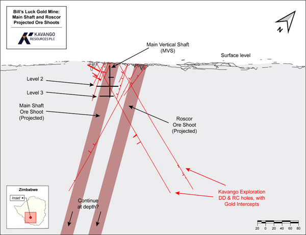
FIGURE 1: Long Section looking NE of the projected ore shoots at Main Shaft and Roscor Shaft, with overlays of current mine workings (to 3 Level), and gold intercepts from previous exploration drilling.
The drilling program is designed to inform a resource estimation from within the current three gold producing areas at Bills Luck (Main Shaft, Roscor Shaft, and West Shaft) along 200m of horizontal strike and to a vertical depth of 150m (5 Level). Multiple holes will be drilled from the same collar positions to intercept the ore shoots at different vertical depths. Current mining operations at Main Shaft extend to 90m vertical depth (3 Level).
The strike at Bill's Luck remains open in both directions for future exploration. In addition, recent structural analysis at Bill's Luck (announced >>> 28 July 2025) suggests the ore shoots are also open at depth.
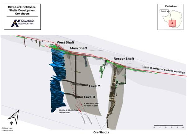
FIGURE 2: Oblique Long Section looking north through Bill's Luck, showing mined out areas around Main Shaft, Roscor Shaft and West Shaft, together with surface artisanal workings along the open strike. Also displayed are the recently announced two significant intersections from underground diamond drilling demonstrating an increase of width and grade below 3 Level.
The start of both diamond and RC drilling is aimed at establishing a maiden MRE capable of supporting commercial mining and processing operations for a minimum of three years. This work is a key step toward a near-term investment decision to install a 200tpd pilot scale production plant, with the goal of increasing ore processing capacity to 250tpd by the first half of 2026.
Kavango's technical team, through careful interpretation of recent structural mapping and analysis, has recognised the possibility for a series of high-grade ore shoots along the mineralised strike at Bill's Luck, including the Main Shaft, Roscor Shaft and West Shaft zones. The Company believes that successfully defining these ore shoots could not only confirm the viability of a three-year mine life but also open up targets for future exploration and development.
The initial phase of the diamond drilling programme will comprise approximately 1,400m focused on confirming the structure, width and continuity of the gold mineralisation around the Main Shaft and between Roscor and West Shafts. This will be complemented by an initial RC drilling campaign of up to 1,400m, aimed at testing near-surface mineralisation along strike to support future mine life planning and resource growth.
Should these campaigns deliver positive results, Kavango has the option to expand the programmes through additional infill drilling. This would enhance confidence in resource estimates, support detailed mine planning, and potentially justify a much larger production profile and extension of mine life in the future.
Kavango's confidence in Bill's Luck is underpinned by recent underground drilling, which yielded two high-grade gold intercepts and confirmed that mineralisation continues from the current mining level (3 Level) to at least 4 Level. These results suggest that the deposit could host a much larger gold system than initially anticipated and support the Company's belief that Bill's Luck has the potential to sustain gold production far beyond the initial three-year resource target.
With the commencement of this resource drilling programme, Kavango is positioning itself to take full advantage of Bill's Luck's emerging potential and to create a strong, cash-generative platform for future growth.
Bill's Luck Area - Structural and Mineralisation Overview
The Bill's Luck area, situated in the southern portion of the Balmoral Magmatic Complex within the Upper Greenstone Belt of the Filabusi region, is structurally complex and highly prospective for gold exploration with several historic mines. The area forms part of a polymetamorphic terrane affected by multiple deformation phases, with the D2 tectono-metamorphic event playing a dominant role in shaping the current structural architecture.
During the D2 tectono-metamorphic event, the Balmoral Complex underwent greenschist facies metamorphism and intense folding, resulting in a characteristic fabric of intersecting foliations and NE-plunging lineations. Strain during the later D2 phase became strongly partitioned into a network of dextral oblique shear zones trending parallel to regional-scale fold axial planes.
These D2 shear zones are the primary structural controls for gold mineralisation and are associated with transpressional deformation.
Bill's Luck Mine
Kavango's Bill's Luck Mine hosts a major shear zone with several minor parallel and splay structures, which the Company's technical team interprets as containing numerous mineralised reefs. The main structure changes orientation from ESE to SSE in its eastern segment, forming a trailing imbricated termination suggestive of a favourable dilation zone for mineral deposition and the location of at least one inferred "ore shoot".
Gold mineralisation at Bill's Luck is structurally and hydrothermally controlled, predominantly occurring within and along the margins of these shear zones. Alteration is characterised by quartz-sericite-chlorite assemblages with disseminated sulphides, often vein-controlled and associated with syntectonic quartz-sulphide veins.
Zones of higher vein density and alteration coincide with areas of stronger deformation, with quartz boudinage, pressure shadows, and mylonitic veins serving as key mineral traps. Late stage mineralised veins also crosscut the earlier mylonitic fabric, indicating prolonged and possibly multi-phase mineralisation.
The structural complexity, combined with the presence of high-strain domains, linking shear structures, and favourable vein-hosting environments, makes the Bill's Luck area a high-potential target for structurally-controlled gold exploration within a dextral transpressional regime.
Kavango's Operations in Zimbabwe
Kavango is exploring for gold deposits in Zimbabwe that have the potential to be developed into commercial scale production quickly through modern mechanised mining and processing. The Company is targeting both open-pit and underground opportunities.
Kavango has two projects on the Filabusi greenstone belt, Hillside and Nara.
Kavango owns 100% of the Hillside Gold Project, having exercised its option in April 2024. Here, the Company has three high priority targets it aims to bring into production over the next 18 months: Bill's Luck, Steenbok and Nightshift. At Nightshift, Kavango is investigating the potential for a selective open-pit mining operation, followed by underground mechanised mining. Meanwhile, at Steenbok, Kavango is pursuing a high-grade mechanised underground mining opportunity. Kavango is currently analysing the latest drill data from Bill's Luck and will provide an update shortly.
In addition, Kavango will soon acquire 100% of the Nara Gold Project, having exercised its option in June 2025. Here, the Company is exploring for a large-scale, mechanisable underground gold deposit. The primary target zone is around the historic N1 mine, where the Company is assessing the potential to expand artisanal workings both at depth and along strike.
Further information in respect of the Company and its business interests is provided on the Company's website at www.kavangoresources.com and on X at @KavangoRes.
For further information please contact:
Kavango Resources plc
Ben Turney
+46 7697 406 06
Shard Capital (Broker)
Damon Heath
+44 (0) 207 186 9952
BlytheRay (Financial PR)
Tim Blythe/Megan Ray/Said Izagaren
kavango@blytheray.com
Tel: +44 207 138 3204
Kavango Competent Person Statement
The technical information contained in this announcement pertaining to mining has been compiled by Mr Craig Hatch, a Competent Person and a member of a Recognised Professional Organisations (ROPO). Craig Hatch has sufficient experience that is relevant to the style of mining and type of deposit under consideration and to the activities being proposed to qualify as a Competent Person as defined in the 2012 Edition of the Australasian Code for Reporting of Exploration Results, Mineral Resources and Ore Reserves (JORC 2012). Craig is the Principal Mining Engineer of Minorex Pty Ltd and a consultant to Kavango Resources and is a member of the Australasian Institute of Mining and Metallurgy (AusIMM), a recognised professional organisation.
The technical information contained in this announcement pertaining to geology and exploration have been compiled by Mr David Catterall, a Competent Person and a member of a Recognised Professional Organisations (ROPO). David Catterall has sufficient experience that is relevant to the style of mineralisation and type of deposit under consideration and to the activity being undertaken to qualify as a Competent Person as defined in the 2012 Edition of the Australasian Code for Reporting of Exploration Results, Mineral Resources and Ore Reserves (JORC 2012). David is the principal geologist at Tulia Blueclay Limited and a consultant to Kavango Resources. David Catterall is a member of the South African Council for Natural Scientific Professions, a recognised professional organisation.
Kavango Resources plc Sampling Techniques and Data for Hillside Project Diamond Drilling. Zimbabwe
Last updated: 5th August 2025
(Criteria in this section apply to all succeeding sections)
JORC Code. 2012 Edition - Table 1 reportSection 1 Sampling Techniques and Data(Criteria in this section apply to all succeeding sections.) |
||
|
Criteria |
JORC Code explanation |
Commentary |
|
Sampling techniques |
Nature and quality of sampling (e.g. cut channels. random chips. or specific specialised industry standard measurement tools appropriate to the minerals under investigation. such as down hole gamma sondes. or handheld XRF instruments. etc). These examples should not be taken as limiting the broad meaning of sampling. |
· The information in this release relates to the technical details from the Company's exploration and drilling program at Hillside Project which lies within the Filabusi Greenstone Belt, Matabeleland, Zimbabwe. · The current planned Resource drilling programme will comprise diamond drilling and reverse circulation (RC) drilling · Surface Diamond drilling uses HQ & NQ size drill bits. · Core is cut into two using a commercial core saw adjacent to the Ori line to produce two splits as mirror images with regards to igneous textures, sedimentary bedding where possible structural fabric. · Sampling of the diamond drill core is carried out with half core samples taken from the entire hole. · Underground Diamond drilling uses AXT dill bits producing 30.5mm cores. · Sampling of the underground core uses the whole core (which is deemed too small to cut) and samples are taken from the entire hole. · No orientation was possible on the underground drill core. · All core samples are taken based on geological contacts, and/or of up to approximately 1m in length. The minimum sample width is 30cm to cater for distinct quartz veins which may be diluted and obscured if 1m widths were to be maintained. · Surface RC drilling uses 6.5"and 4.5" conventional down the hole hammers. · RC drill chips are sampled after splitting with a commercial 3 tier riffle splitter. · Reverse Circulation samples are 1m samples collected from the cyclone. · Two samples are taken using a riffle splitter from the original 1m sample. · Core and RC chip samples are submitted for a 25g fire assay with AAS finish to Performance Laboratories (Pvt) Ltd., at Harare, Zimbabwe. · Selected samples will be sent to a check lab, ALS laboratories, Johannesburg, for referee fire assay comparison. · Kavango routinely takes pXRF readings along the core using an Olympus Vanta on Geochem 3 beam mode 60 seconds. · The pXRF readings are used only as a guide for lithological characterisation and alteration and not for resource estimation. |
|
Include reference to measures taken to ensure sample representivity and the appropriate calibration of any measurement tools or systems used |
· All Kavango's drill samples are geologically logged by suitably qualified geologists on site. · Sample representativity is ensured where possible by drilling perpendicular to structures of interest, and by the sample preparation technique in the laboratory. · The entire borehole is sampled based on geological logging, with the ideal sampling interval being representative of lithology for diamond core and 1m intervals for RC chip samples. · Individual samples are weighed at the field camp. · Upon arrival at Performance lab, the samples are dried at +/- 105 deg Celsius for 8 to 12 hours. · Entire sample is crushed to 100% passing 4.75mm. The crushers have inline rotary splitters that split off 500g of sample that is pulverized. · The 500g split is pulverized in a Rocklabs pot and puck pulveriser with 85% passing minus 75μm. · A standard 25g aliquot is used for Fire Assay. · Following industry best practice. a series of certified reference materials (CRM's), duplicates and blanks were included for QAQC as outlined further below. |
|
|
Aspects of the determination of mineralisation that are Material to the Public Report. |
||
|
In cases where 'industry standard' work has been done this would be relatively simple (e.g. 'reverse circulation drilling was used to obtain 1 m samples from which 3 kg was pulverised to produce a 30 g charge for fire assay'). In other cases. more explanation may be required, such as where there is coarse gold that has inherent sampling problems. Unusual commodities or mineralisation types (e.g. submarine nodules) may warrant disclosure of detailed information. |
||
|
Drilling techniques |
Drill type (e.g. core. reverse circulation. open-hole hammer. rotary air blast. auger. Bangka. sonic. etc) and details (e.g. core diameter. triple or standard tube. depth of diamond tails. face-sampling bit or other type. whether core is oriented and if so. by what method. etc). |
· The surface diamond drill holes were drilled using a diamond drill operated by Equity Drilling Limited. · Equity use HQ and NQ diameter conventional core barrel. · The underground diamond drill holes were drilled by DHB drilling, Zimbabwe · The RC drill holes were drilled by Spartan Drilling. · Spartan routinely use conventional DTH of 6.5"and 4.5"
|
|
Drill sample recovery |
Method of recording and assessing core and chip sample recoveries and results assessed. |
· Core recovery was monitored closely throughout. · Recovery in rock was >95%. · RC sample recovery is monitored through weighing of samples prior to splitting. · Weight and volumes recovered are noted and recovery is generally very good. · Any voids are noted. |
|
Measures taken to maximise sample recovery and ensure representative nature of the samples. |
· Samples prepared for assay are taken consistently from the same side of the core cutting line to avoid bias. · Geologists frequently check the core cutting procedures to ensure the core cutter splits the core correctly in half. · Underground diamond drill cores were not split and the whole core was sampled and submitted for assay · Core samples for assay are selected within logged geological, structural, mineralisation and alteration constraints. · Samples are collected from distinct geological domains with sufficient width to avoid overbias. · RC samples are split using a commercial 3 tier riffle splitter to provide 2 representative samples of 1kg from each 1m sample |
|
|
Whether a relationship exists between sample recovery and grade and whether sample bias may have occurred due to preferential loss/gain of fine/coarse material. |
· For Diamond drilling sample recovery was generally very good and as such it is not expected that any such bias exists. · For RC drill sample recovery was generally very good and as such it is not expected that any bias exists. |
|
|
Logging |
Whether core and chip samples have been geologically and geotechnically logged to a level of detail to support appropriate Mineral Resource estimation. mining studies and metallurgical studies. |
· Kavango's Diamond drill core and RC drill chips are logged by a team of qualified geologists using predefined lithological, mineralogical, physical characteristic (colour, weathering etc) and logging codes. · Diamond drill core was marked up on site and Geotechnical logging was completed at the rig to ensure recoveries were adequately recorded. · Lithological, structural, alteration and mineralisation are logged at camp. · The core and chip samples are securely stored at the base camp. · The geologists on site follow industry best practice and standard operating procedure for both diamond core and RC drilling. · The core is photographed wet and dry. · pXRF and magnetic susceptibility data are also captured at consistent intervals on both diamond drill core and RC drill chips. This data is only used as a guide for lithological and alteration mapping and interpretation. · Density measurements for drill core were determined by Archimedes density measurements i.e. using a precision balance to weigh sample in air and in submerged in water. A representative piece of core was selected from each sample for density measurement. · The QA/QC compilation of all logging results are stored and backed up on a data cloud. |
|
Whether logging is qualitative or quantitative in nature. Core (or costean. channel. etc) photography. |
· All logging is conducted in accordance with Kavango's SOP and standard published logging charts and classification for grain size, abundance, colour and lithologies to maintain a qualitative and semi-quantitative standard based on visual estimation. · Magnetic susceptibility readings are also taken every metre and/or half metre using a ZH Instruments SM-20/SM-30 reader. · All core drilled was photographed wet and dry according to industry best practice. |
|
|
The total length and percentage of the relevant intersections logged. |
· 100% of all recovered intervals are geologically logged. |
|
|
Sub-sampling techniques and sample preparation |
If core. whether cut or sawn and whether quarter. half or all cores taken. |
· Selected diamond core intervals are cut in half with a commercial core cutter. using a 2mm thick blade · One half is sampled for analysis while the other half is kept for reference. · Some of the retained half core is submitted for metallurgical test work. · For selected petrographic samples core is quartered. · Underground diamond drill cores are not cut and the whole core is sampled and submitted for assay. |
|
For all sample types. the nature. quality and appropriateness of the sample preparation techniques |
· Field sample preparation is suitable for both core and RC samples. · RC samples are weighed at site as they come off the cyclone and every effort is made to ensure each metre sample is representative of the length drilled, with proportional volume and weight recorded. · The laboratory sample preparation technique is considered appropriate and suitable for the core samples and as well as for the expected grades. |
|
|
Quality control procedures adopted for all sub-sampling stages to maximise representivity of samples. |
· Kavango's standard field QAQC procedures for drilling samples include the field insertion of blanks, an appropriate selection of standards, field duplicates, replicates, and selection of requested laboratory pulp and coarse crush duplicates. · These are being inserted at a rate of 2.5- 5% each to ensure an appropriate rate of QAQC. |
|
|
Measures taken to ensure that the sampling is representative of the in-situ material collected. including for instance results for field duplicate/second-half sampling. |
· Sampling is deemed appropriate for the type of survey and equipment used. · Quarter diamond core duplicates are not deemed appropriate for this type of gold mineralisation. This could potentially bias the sample due to the nugget effect and vein hosted nature of the mineralisation and would reduce the sample volume. · Laboratory duplicates are produced from the crushed and milled core. · RC samples are split to provide representative duplicate samples using a commercial riffle splitter. |
|
|
Whether sample sizes are appropriate to the grain size of the material being sampled. |
· On occasions gold from this project may be coarse, therefore, some nugget effect is expected. This is minimised by using the largest diameter of core possible with the available equipment, and by utilising halved rather than quartered core for assay. |
|
|
Quality of assay data and laboratory tests |
The nature. quality and appropriateness of the assaying and laboratory procedures used and whether the technique is considered partial or total. |
· A company audit was made of the assay laboratory in this case Performance Laboratories before it was engaged. · The digest and fire assay technique provide a total analysis method. · Between 5% and 20% of submitted samples consisted of additional blank, duplicate (lab duplicate from splitting the pulp), and standard samples. · Round robin and accreditation results for the laboratory were reviewed and considered acceptable. · The company's QAQC samples, including standards, are considered to confirm acceptable bias and precision with no contamination issues identified. |
|
For geophysical tools. spectrometers. handheld XRF instruments. etc. the parameters used in determining the analysis including instrument make and model. reading times. calibrations factors applied and their derivation. etc.
Nature of quality control procedures adopted (e.g. standards. blanks. duplicates. external laboratory checks) and whether acceptable levels of accuracy (i.e. lack of bias) and precision have been established. |
· Kavango use ZH Instruments SM20 and SM30 magnetic susceptibility meters for measuring magnetic susceptibilities and readings are randomly repeated to ensure reproducibility and consistency of the data. · An Olympus Vanta C-series pXRF instrument is used in 3-beam geochemical mode with reading times of 60 seconds in total. Measurements are taken on clean dry core. · For the pXRF results no user factor was applied as per Kavango's SOP. The units are calibrated daily with their respective calibration disks. · All QAQC samples were reviewed for precision and accuracy. Results were deemed repeatable and representative: · For pXRF appropriate certified reference materials are inserted on a ratio of 1:25 samples. · Repeat readings are taken every 25 samples. and blank samples are inserted every 25 samples. · QAQC samples are reviewed for consistency. · pXRF CRM values show a slight positive bias. including for Cu. · At low levels (<10ppm) silver values in particular are scattered. · When laboratory assay results are received blank, standard, and duplicate values are reviewed to monitor lab performance. · Select low, moderate and high-grade assay samples will be sent for check analysis at an internationally accredited laboratory for referee comparison |
|
|
|
· Performance Lab insert their own CRM's, duplicates and blanks and follow their own SOP for quality control. · Performance Laboratories are locally accredited but not internationally accredited. · Kavango is aware of this and carries out exhaustive QAQC checks and works with Performance to ensure accuracy and repeatability. · Several select samples, including one entire hole from a twinned pair have been sent to Performance in Zimbabwe and ALS Laboratories in South Africa, with comparable and acceptable results. · Further external referee laboratory checks will be carried out as and when sufficient holes have been drilled to warrant. |
|
|
Verification of sampling and assaying |
The verification of significant intersections by either independent or alternative company personnel. |
· All drill core intersections were verified by peer review. · The Company's internal CP reviewed sampling and has visited site and the laboratory to verify protocols. · Assay data was received as assay certificates and cross checked against sample submission data to ensure a correct match. |
|
The use of twinned holes. |
· In previous drilling at Bills Luck, one hole was abandoned, and the follow-up hole was designed and drilled as a twin hole. |
|
|
Documentation of primary data. data entry procedures. data verification. data storage (physical and electronic) protocols. |
· All data is electronically stored with peer review of data processing and modelling. · Data entry procedures are standardised in SOP data checking and verification routine. · Data storage is on a cloud storage facility with access controls and automatic backups. |
|
|
Discuss any adjustment to assay data. |
· No adjustments were made to assay data. |
|
|
Location of data points |
Accuracy and quality of surveys used to locate drill holes (collar and down-hole surveys). trenches. mine workings and other locations used in Mineral Resource estimation. |
· Kavango's surface drill collar coordinates are captured by using handheld Garmin GPS and verified by a second handheld Garmin GPS. · Drill holes are routinely re-surveyed with differential DGPS at regular intervals to ensure sub-metre accuracy as and when sufficient holes warrant. · Downhole surveys of drill holes are done using an AXIS Champ Mag tool or the Champ Gyro (for DTH). · Underground drill holes are surveyed by a qualified underground surveyor using measured in pegs. |
|
Specification of the grid system used. |
· The grid system used is UTM 35S Arc 1950. All reported coordinates are referenced to this grid. |
|
|
Quality and adequacy of topographic control. |
· Topographic control is based on satellite survey data collected at 30m resolution. Quality is considered acceptable. |
|
|
Data spacing and distribution |
Data spacing for reporting of Exploration Results. Whether the data spacing. and distribution is sufficient to establish the degree of geological and grade continuity appropriate for the Mineral Resource and Ore Reserve estimation procedure(s) and classifications applied. |
· Data spacing and distribution of all survey types is deemed appropriate for the type of survey and equipment used. · The drilling programs are designed to target the multiple interpreted parallel auriferous veins at the Bills Luck Mine on the Prospect Claims.
|
|
Whether sample compositing has been applied. |
· No composite sampling have been done |
|
|
Orientation of data in relation to geological structure |
Whether the orientation of sampling achieves unbiased sampling of possible structures and the extent to which this is known. considering the deposit type. |
· Drill spacing is currently variable but is considered appropriate for this stage of exploration. · Hole orientation is designed to intersect the target structures as perpendicular as is practical. · This is considered appropriate for the geological setting and for the known mineralisation styles. |
|
If the relationship between the drilling orientation and the orientation of key mineralised structures is considered to have introduced a sampling bias. this should be assessed and reported if material. |
· Existence, and orientation of preferentially mineralised structures is not yet fully understood but current available data indicates mineralisation occurs within steep. sub-vertical structures, with the possibility of plunging "ore-shoots". · The drillholes are inclined towards the target, which is understood to dip towards the drillhole at a steep angle (actual geometry to be confirmed by a second hole on section in the future). · The relatively short sample length (typically 1 m) allows for relatively accurate localization of mineralisation. · No significant sampling bias is therefore expected. |
|
|
Sample security |
The measures taken to ensure sample security. |
· Diamond core and RC drill chips are stored together in a secure facility at the field office. · Sample bags are logged, tagged, double bagged and sealed in plastic bags stored at the field office. · Samples are stored in a locked company compound at site and in a locked container in Bulawayo. They are shipped onwards to the analytical facility by a reliable commercial courier. · Sample security includes a chain-of-custody procedure that consists of filling out sample submittal forms that are sent to the laboratory with sample shipments to make certain that all samples are received by the laboratory. · Prepared samples are transported to the analytical laboratory in sealed bags that are accompanied by appropriate paperwork. including the original sample preparation request numbers and chain-of-custody forms. |
|
Audits or reviews |
The results of any audits or reviews of sampling techniques and data. |
· The CP has visited both site and the laboratory utilised and considered practices and SOPs at both as acceptable. · The CP reviewed all data, and spot-checked significant values versus certificates. |
JORC Section 2 Reporting of Exploration Results
(Criteria listed in the preceding section also apply to this section.)
|
Criteria |
JORC Code explanation |
Commentary |
|||||||||||||||||||||||||||||||||||||||||||||||||||||||||||||||||||||||||||||||||||||||||||||||||||||||||||||||||||||||||||||||||||||||||||||||||||||||||||||||||||||||||||||||||||||||||||||||||||||||||||||||||||||||||||||||||||||||||||||||||||||||||||||||||||||||||||||||||||||||||||||||||||||||||||||||||||||||||||||||||||||||||||||||||||||||||||||||||||||||||||||||||||||||||||||||||||||||||||||||||||||||||||||||||||||||||||||||||||||||||||||||||||||||||||||||||||||||||||||||||
|
Mineral tenement and land tenure status |
Type. reference name/number. location and ownership including agreements or material issues with third parties such as joint ventures. partnerships. overriding royalties. native title interests. historical sites. wilderness or national park and environmental settings. The security of the tenure held at the time of reporting along with any known impediments to obtaining a licence to operate in the area. |
· The Hillside Project consists of 44 gold claims. · Kavango entered into an option agreement with the vendors, dated 25 July 2023. · This was exercised on 23 April 2024 with respect to Hillside and Leopard South. · Leopard North remains subject to a call option valid to June 2025. · Transfer of the Claims is presently underway. · More details are provided here https://polaris.brighterir.com/public/kavango_resources_plc/news/rns/story/w9nq44r |
|||||||||||||||||||||||||||||||||||||||||||||||||||||||||||||||||||||||||||||||||||||||||||||||||||||||||||||||||||||||||||||||||||||||||||||||||||||||||||||||||||||||||||||||||||||||||||||||||||||||||||||||||||||||||||||||||||||||||||||||||||||||||||||||||||||||||||||||||||||||||||||||||||||||||||||||||||||||||||||||||||||||||||||||||||||||||||||||||||||||||||||||||||||||||||||||||||||||||||||||||||||||||||||||||||||||||||||||||||||||||||||||||||||||||||||||||||||||||||||||||
|
Exploration done by other parties |
Acknowledgment and appraisal of exploration by other parties. |
· The project contains a historic high-grade mine Bills Luck, which has a history of intermittent gold production from 1916 to 1950, yielding 17,000 oz at an average grade of 7.7g/t. After 1950, the mine saw only small-scale sand retreatment and surface workings. · It is currently being mined by artisanal miners, who are under contract, milling the ore at Bill's Luck stamp mill. |
|||||||||||||||||||||||||||||||||||||||||||||||||||||||||||||||||||||||||||||||||||||||||||||||||||||||||||||||||||||||||||||||||||||||||||||||||||||||||||||||||||||||||||||||||||||||||||||||||||||||||||||||||||||||||||||||||||||||||||||||||||||||||||||||||||||||||||||||||||||||||||||||||||||||||||||||||||||||||||||||||||||||||||||||||||||||||||||||||||||||||||||||||||||||||||||||||||||||||||||||||||||||||||||||||||||||||||||||||||||||||||||||||||||||||||||||||||||||||||||||||
|
Geology |
Deposit type. geological setting and style of mineralisation. |
· Bills Luck lies near the southern contact of the Filabusi gold belt and the Bulawayan Basement Schists. Younger intrusive granites bound it to the north. · Gold mineralization appears to be associated with multiple sub parallel quartz veins that occur in fine grained massive, sheared granite. · The general azimuth of the auriferous veins is 110o TN (dipping steeply to the NNE) · Bills Luck, which has a history of intermittent gold production from 1916 to 1950, yielding 17,000 oz at an average grade of 7.7g/t. After 1950, the mine saw only small-scale sand retreatment and surface workings.
|
|||||||||||||||||||||||||||||||||||||||||||||||||||||||||||||||||||||||||||||||||||||||||||||||||||||||||||||||||||||||||||||||||||||||||||||||||||||||||||||||||||||||||||||||||||||||||||||||||||||||||||||||||||||||||||||||||||||||||||||||||||||||||||||||||||||||||||||||||||||||||||||||||||||||||||||||||||||||||||||||||||||||||||||||||||||||||||||||||||||||||||||||||||||||||||||||||||||||||||||||||||||||||||||||||||||||||||||||||||||||||||||||||||||||||||||||||||||||||||||||||
|
Drill hole Information |
A summary of all information material to the understanding of the exploration results including a tabulation of the following information for all Material drill holes: easting and northing of the drill hole collar elevation or RL (Reduced Level - elevation above sea level in metres) of the drill hole collar dip and azimuth of the hole down hole length and interception depth hole length. If the exclusion of this information is justified on the basis that the information is not Material, and this exclusion does not detract from the understanding of the report. the Competent Person should clearly explain why this is the case. |
· A summary table of all planned Kavango drill holes that form the focus of the current program are presented below and will be updated in future announcements.. · The holes will be surveyed and sited using a handheld GPS · Upon completion of drilling a DGPS survey will be completed by professional surveyors. · Position format: UTM UPS; Map datum Arc 1950 Zone 35S.
|
|||||||||||||||||||||||||||||||||||||||||||||||||||||||||||||||||||||||||||||||||||||||||||||||||||||||||||||||||||||||||||||||||||||||||||||||||||||||||||||||||||||||||||||||||||||||||||||||||||||||||||||||||||||||||||||||||||||||||||||||||||||||||||||||||||||||||||||||||||||||||||||||||||||||||||||||||||||||||||||||||||||||||||||||||||||||||||||||||||||||||||||||||||||||||||||||||||||||||||||||||||||||||||||||||||||||||||||||||||||||||||||||||||||||||||||||||||||||||||||||||
|
|||||||||||||||||||||||||||||||||||||||||||||||||||||||||||||||||||||||||||||||||||||||||||||||||||||||||||||||||||||||||||||||||||||||||||||||||||||||||||||||||||||||||||||||||||||||||||||||||||||||||||||||||||||||||||||||||||||||||||||||||||||||||||||||||||||||||||||||||||||||||||||||||||||||||||||||||||||||||||||||||||||||||||||||||||||||||||||||||||||||||||||||||||||||||||||||||||||||||||||||||||||||||||||||||||||||||||||||||||||||||||||||||||||||||||||||||||||||||||||||||||
|
Data aggregation methods |
In reporting Exploration Results. weighting averaging techniques. maximum and/or minimum grade truncations (e.g. cutting of high grades) and cut-off grades are usually Material and should be stated. Where aggregate intercepts incorporate short lengths of high-grade results and longer lengths of low-grade results. the procedure used for such aggregation should be stated and some typical examples of such aggregations should be shown in detail. The assumptions used for any reporting of metal equivalent values should be clearly stated. |
· Outstanding results will be reported as and when they are available and have been reviewed for QAQC and used for interpretation
|
|||||||||||||||||||||||||||||||||||||||||||||||||||||||||||||||||||||||||||||||||||||||||||||||||||||||||||||||||||||||||||||||||||||||||||||||||||||||||||||||||||||||||||||||||||||||||||||||||||||||||||||||||||||||||||||||||||||||||||||||||||||||||||||||||||||||||||||||||||||||||||||||||||||||||||||||||||||||||||||||||||||||||||||||||||||||||||||||||||||||||||||||||||||||||||||||||||||||||||||||||||||||||||||||||||||||||||||||||||||||||||||||||||||||||||||||||||||||||||||||||
|
Relationship between mineralisation widths and intercept lengths |
These relationships are particularly important in the reporting of Exploration Results. If the geometry of the mineralisation with respect to the drill hole angle is known. its nature should be reported. If it is not known and only the down hole lengths are reported. there should be a clear statement to this effect (eg 'down hole length. true width not known'). |
· Down hole intersection widths will be used throughout until such time as enough data is available to provide true width intersections. · Most of the drill intersections are into steep to vertically dipping units. True thickness is presently unknown and will be determined based on additional drilling. · All measurements state that downhole lengths have been used as the true width cannot yet be established by the current drilling. · Due to the structural control on the mineralisation and the anastomosing nature of the shears, together with an inferred plunge more drilling is required to provide accurate measurements for true thickness |
|||||||||||||||||||||||||||||||||||||||||||||||||||||||||||||||||||||||||||||||||||||||||||||||||||||||||||||||||||||||||||||||||||||||||||||||||||||||||||||||||||||||||||||||||||||||||||||||||||||||||||||||||||||||||||||||||||||||||||||||||||||||||||||||||||||||||||||||||||||||||||||||||||||||||||||||||||||||||||||||||||||||||||||||||||||||||||||||||||||||||||||||||||||||||||||||||||||||||||||||||||||||||||||||||||||||||||||||||||||||||||||||||||||||||||||||||||||||||||||||||
|
Diagrams |
Appropriate maps and sections (with scales) and tabulations of intercepts should be included for any significant discovery being reported These should include. but not be limited to a plan view of drill hole collar locations and appropriate sectional views. |
· N/A |
|||||||||||||||||||||||||||||||||||||||||||||||||||||||||||||||||||||||||||||||||||||||||||||||||||||||||||||||||||||||||||||||||||||||||||||||||||||||||||||||||||||||||||||||||||||||||||||||||||||||||||||||||||||||||||||||||||||||||||||||||||||||||||||||||||||||||||||||||||||||||||||||||||||||||||||||||||||||||||||||||||||||||||||||||||||||||||||||||||||||||||||||||||||||||||||||||||||||||||||||||||||||||||||||||||||||||||||||||||||||||||||||||||||||||||||||||||||||||||||||||
|
Balanced reporting |
Where comprehensive reporting of all Exploration Results is not practicable. representative reporting of both low and high grades and/or widths should be practiced to avoid misleading reporting of Exploration Results. |
· All completed holes will be logged, sampled and dispatch as they are processed. · Outstanding results will be reported as and when they are available and have been reviewed for QAQC and used for interpretation |
|||||||||||||||||||||||||||||||||||||||||||||||||||||||||||||||||||||||||||||||||||||||||||||||||||||||||||||||||||||||||||||||||||||||||||||||||||||||||||||||||||||||||||||||||||||||||||||||||||||||||||||||||||||||||||||||||||||||||||||||||||||||||||||||||||||||||||||||||||||||||||||||||||||||||||||||||||||||||||||||||||||||||||||||||||||||||||||||||||||||||||||||||||||||||||||||||||||||||||||||||||||||||||||||||||||||||||||||||||||||||||||||||||||||||||||||||||||||||||||||||
|
Other substantive exploration data |
Other exploration data. if meaningful and material. should be reported including (but not limited to): geological observations; geophysical survey results; geochemical survey results; bulk samples - size and method of treatment; metallurgical test results; bulk density. groundwater. geotechnical and rock characteristics; potential deleterious or contaminating substances. |
· Geophysical work has been done previously, comprising Gradient Array IP and Stacked Schlumberger Sections · A regional structural mapping programme has been completed and included detailed structural analysis of portions of specific holes. · Further structural work is scheduled |
|||||||||||||||||||||||||||||||||||||||||||||||||||||||||||||||||||||||||||||||||||||||||||||||||||||||||||||||||||||||||||||||||||||||||||||||||||||||||||||||||||||||||||||||||||||||||||||||||||||||||||||||||||||||||||||||||||||||||||||||||||||||||||||||||||||||||||||||||||||||||||||||||||||||||||||||||||||||||||||||||||||||||||||||||||||||||||||||||||||||||||||||||||||||||||||||||||||||||||||||||||||||||||||||||||||||||||||||||||||||||||||||||||||||||||||||||||||||||||||||||
RNS may use your IP address to confirm compliance with the terms and conditions, to analyse how you engage with the information contained in this communication, and to share such analysis on an anonymised basis with others as part of our commercial services. For further information about how RNS and the London Stock Exchange use the personal data you provide us, please see our Privacy Policy.
