Serval Resources Plc - Results from Geophysical Surveys on PL082 and PL231 in the Kalahari Copper Belt, Botswana
("Serval" or the "Company")
Results from Geophysical Surveys on PL082 and PL231
in the Kalahari Copper Belt,
Serval has identified the utilisation of a combination of geophysical techniques as being key to exploration success in the KCB, where the geology of the underlying copper mineralisation is overlain by sand cover of varying depths.
Highlights
    --   The surveys utilised a combination of three geophysical methods to
        provide insight into the thickness of the sand cover overlying the
        target Kalahari Copperbelt units known to hold copper-silver
        mineralisation, as well as to confirm the efficacy of the exploration
        approach to identify the target structures
    --   PL082 (on strike to Cobre Limited’s Ngami project): interpretation of
        results indicates that underlying KCB geology can be observed through
        the Karoo volcanic sequences, as well as clear areas of more conductive
        and more resistive units, being possible indications of the target
        Ngwako pan and D’Kar formation contact; these zones will be the focus of
        future exploration efforts
    --   PL231: identification of an interpreted anticlinal structure where the
        Company will focus future exploration efforts, plus an indication of the
        variation in depth of sand cover to bedrock across the licence area,
        which will greatly assist decision making for the Company in using soil
        geochemistry as an exploration tool
CEO,
"I am very pleased with the speed at which our team has completed these first geophysical programmes in the KCB, in accordance with the work requirements of our licences, and analysed the results. This limited amount of work has provided the Company with valuable information about the exploration methodology required for exploration success in the KCB, and possible targets on these two licence areas. The Company will utilise the funds raised as part of the recent listing on AIM to move forward with the exploration programmes in order to generate drill ready targets in due course.”
About the Geophysical Surveys
The surveys consisted of two blocks in PL082 and PL231 respectively. Each area was surveyed with ground-based magnetics, time domain electromagnetic (“TDEM”) and Audio-Magnetotellurics (“AMT”). Ground magnetics and TDEM were completed along a total of 67.5 line-kilometres and a total of 299 stations for AMT.
The aim of the programmes is to:
1) provide insight into the thickness of the sand cover overlying the target KCB units known as the D’Kar, Ngwako Pan, and potentially Mamuno Formation;
2) serve as an orientation type survey, to establish which geophysical method, or combination of methods, is best suited for identifying target horizons and/or structures that could host mineralisation; and
3) assess the accuracy and improved results versus regional data for eventual drill hole targeting.
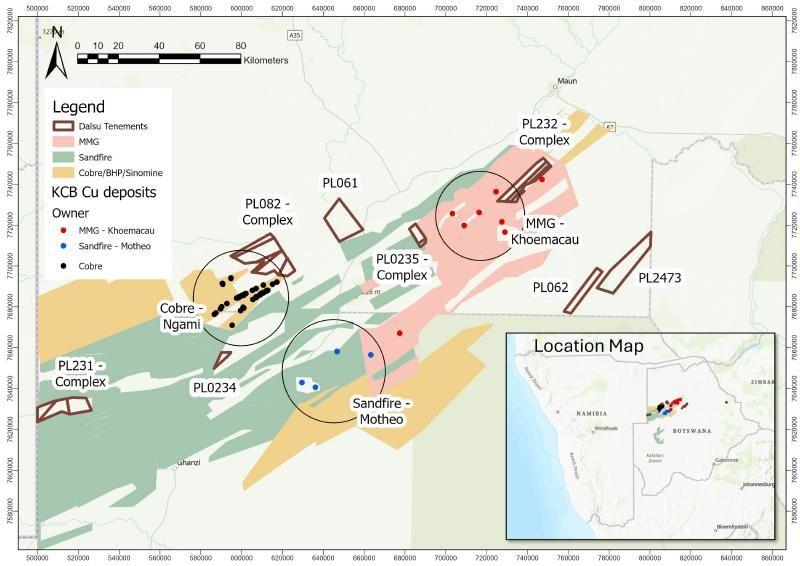
Figure 1: Location of the Company’s licences in the KCB
PL082
PL082 is a priority target for Serval as it is directly adjacent and on strike to Cobre Limited’s
Existing regional data from the
TDEM data indicates clear areas of more conductive and more resistive units, known in the KCB as possible indications of the target Ngwako pan and D’Kar formation contact. These zones will be the focus of future exploration efforts for the Company in these licences.

Figure 2: Structures below the cover sequences interpreted from the magnetic and TDEM data.
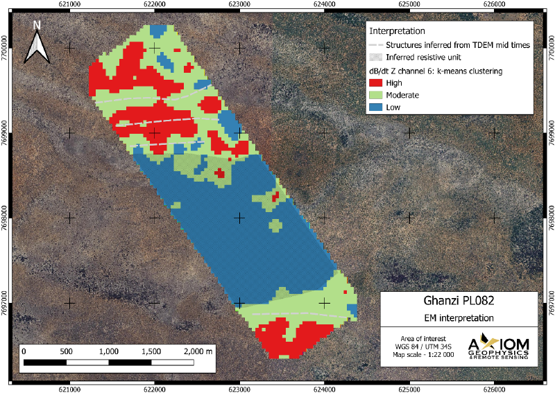
Figure 3: Areas of low and high resistivity as identified with TDEM.
PL231
PL231 is located to the west of the licence package, on the border with
An important interpretation from the AMT data, is an anticlinal structure in the northern part of the licence. Anticlinal structures that interact with the target horizon are known structural traps for mineralisation in the KCB and this feature will be the focus for follow up exploration in this area.
The survey also provided the Company with valuable information about the efficacy of the exploration approach in the KCB. Total Magnetic Intensity, Reduced to Pole, ground magnetic data indicated that features previously identified from the regional airborne magnetic data are defined in much more detail, as well as being shifted by about 100 metres towards the south. The ground magnetic result thereby confirms to the Company that more extensive ground based magnetic field work will more accurately define the underlying KCB geology.
Furthermore, depth to bedrock (thickness of Kalahari sand cover) was interpreted using a combination of TDEM and AMT inversion models and is interpreted to be increasing in depth from about 20 metres in the north to about 90 metres in the south of the licence area. Magnetic lineaments and structures were inferred from the ground based magnetic data. Conductive elements were inferred from the TDEM data and apparent resistivity from the AMT. Generally, the three datasets complement each other well.
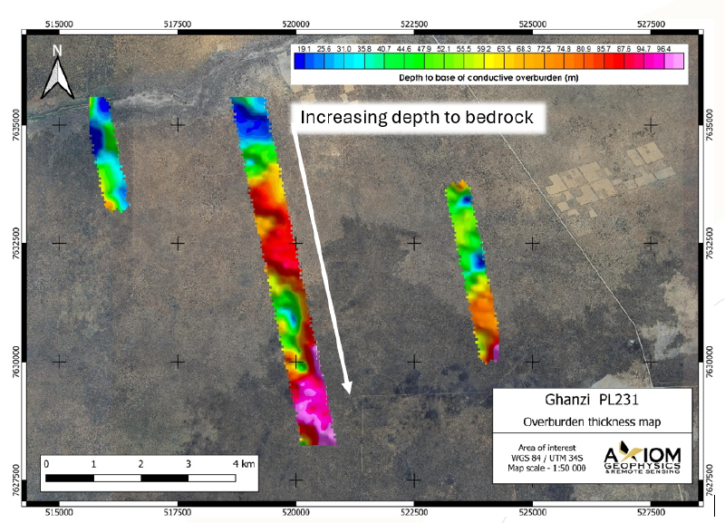
Figure 4: Overburden thickness interpreted using TDEM and MT inversion models.
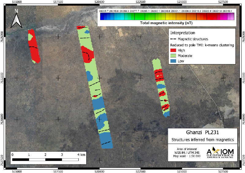
Figure 5: Structures inferred using the reduced to pole TMI
Enquiries:
robin.birchall@servalresources.com
Serval Resources +44 (0) 7711 313 019
Robin Birchall cathy.malins@servalresources.comCathy Malins +44 (0) 7876 796 629
SP Angel (Nominated Advisor and Joint
Broker)
David Hignell
+44 (0) 203 470 0470
Charlie Bouverat Devik Mehta AlbR Capital Limited (Joint Broker)
Lucy Williams +44 (0) 207 469 0930
Duncan Vasey Tavistock Communications (PR)
+44 (0) 20 7920 3150
Charles Vivian servalresources@tavistock.co.ukEliza Logan
THIS ANNOUNCEMENT CONTAINS INSIDE INFORMATION FOR THE PURPOSES OF ARTICLE 7 OF THE MARKET ABUSE REGULATION (EU) 596/2014 AS IT FORMS PART OF
About
For further information, visit:
-- https://servalresources.com/
-- https://x.com/ServalResources
-- https://www.linkedin.com/company/serval-resources/
4348871_4.png 4348871_3.png 4348871_0.jpeg 4348871_1.png 4348871_2.png

